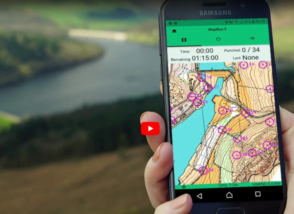
Introduction to MapRun
- The control sites have no visible controls.
- The Start, Finish and all control sites are identified by a GPS signal to your phone.
- An app on your phone or smart watch receives a signal within a few metres of the feature circled on your map.
- A sound notification and the map on your phone confirm you have found the control.
- The printed map is identical to a regular event.
- The video below, gives more information.
The App
All participants need a smart phone or smart watch with the MapRun7 or MapRunG App. A menu on the App (or a QR code short cut) enables you to find the course location. Do not tap Go to Start until you are ready to go.
GPS Signals
MapRun updates itself at set intervals of time. Usually 20 secs, but this is changeable from within the MapRun Menu under Settings. The satellite updates can be affected if you have any overhead covering such as a tree canopies. So sometimes there is no instant reaction when you reach a control. You may need to wait a few seconds to let your phone/watch collect the next cycle of satellite signals.
Navigation
You are strongly recommended to navigate around the courses using the printed paper version of the course. Although possible, it is more difficult using the MapRun course as displayed on the phone, so is not recommended.
For beginner courses you will find the course trail is shown in red and you can activate ‘show me where I am’ if you get lost and need to relocate. This option may not always be available on harder courses.
After your run
Your results can be unloaded and displayed on the app along with others who have run the course. Your GPS track can also be displayed on the app so you can compare routes with others.
Child Safety
In urban areas with road crossings children under 16s must be accompanied by an adult.
Club Night MapRun

In the autumn (end of August to early December) the Tuesday Evening Club Nights feature MapRuns. You can register in advance for a printed map. The locations start with parkland and then use urban area when evenings get darker. Advice and assistance will be available for anyone new to MapRun.
Permanent MapRun Courses

If you wish to run a MapRun course at other times, you can go to the Virtual Orienteering section on British Orienteering’s Go Orienteering page. We normally make a small charge for downloading maps and most of this goes to the MapRun providers who charge us 50p a map.
LEI maps have a QR code and PIN number. The QR code helps you download the map quickly. The PIN number activates run.
For parks where there is a permanent physical course, there are often markers in place. In urban areas there are no markers.